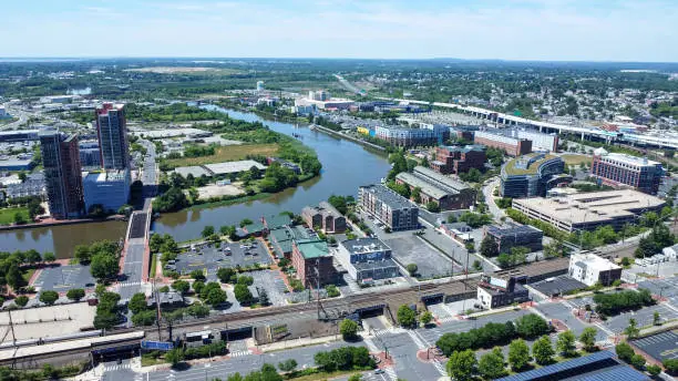
Real estate agents scroll past a lot of listing photos every day. What stops the scroll is a shot no ground camera can pull off: a full aerial view of the property, the yard, and everything nearby. That’s exactly what drone photography for real estate Delaware agents rely on delivers. It’s part of why drone photography helps sell homes faster than photos alone. A drone, technically an unmanned aerial vehicle, gives buyers a bird’s eye view of the property before they ever schedule a showing. This guide breaks down why it works, what it costs, and how to use it well.
At Pixiest Photography, we fly licensed drone sessions for real estate listings across Newark, Wilmington, and Dover. These are the same aerial real estate photos Delaware agents drop straight into their listing packages. Agents ask us the same handful of questions before nearly every shoot. This covers what actually matters.
Why Drone Photography Helps Homes Sell Faster
Buyers judge a listing in seconds, often before they’ve read a single word about it. Aerial photography gives them context a regular photo just can’t. Think lot size, the yard, the street, the block beyond the fence line. According to Zillow, MLS photos that include aerial imagery are far more likely to sell than listings without it, based on Multiple Listing Service data
It’s not just about looking good either. Aerial shots answer questions buyers would have to drive over and check in person. That tends to bring in more serious buyers, ones further along in their search. That’s the whole point of good property marketing.
What Aerial Photos Actually Show Buyers
Ground-level photos do a decent job showing the inside of a home. They fall short once a buyer wants to see the property as a whole. A bird’s eye view property shot shows the full lot, how close the neighbors sit, and whether there’s room for a pool or garden later on. Lot size and acreage photos in particular tend to answer questions buyers would otherwise have to ask directly.
Buyers also want context beyond the property line. Nearby parks, water access, or how a street connects to the rest of the block all become clear from 200 feet up, giving buyers real neighborhood context before they visit. That kind of clarity builds trust before a buyer ever walks through the door.
How Much Does Real Estate Drone Photography Cost
Pricing varies a fair bit based on property size and what’s included in the shoot. At Pixiest Photography, drone photos for home listings start around $350 as a package. Larger homes, video walkthroughs, or twilight photo sessions often cost more than a standard still photo package.
It’s worth weighing that cost against what a faster sale saves everyone involved. A few hundred dollars upfront is a small price next to weeks of extra time on the market.
Is Drone Photography for Real Estate Legal in Delaware
Yes, as long as the operator is an FAA licensed drone pilot. Commercial drone work in the United States falls under FAA Part 107, which requires a licensed remote pilot for any paid aerial photo work. Delaware doesn’t add extra local rules on top of that for most residential listings.
Working with an unlicensed operator puts the agent and the seller at risk. Always ask a drone photographer for proof of their Part 107 certificate first.
How Many Aerial Photos Should a Listing Include
Most agents do well with 8 to 10 aerial shots per listing. That’s fairly standard for aerial photography for property listings across the industry. That range gives buyers enough context without filling the gallery with repeat angles. A mix works best, a few wide establishing shots, a couple closer to the roofline, and one or two showing the surrounding street or lot lines. Strong property listing visuals almost always mix these angles rather than repeating the same shot from slightly different heights.
Video is worth adding too, not just still photos. A short aerial flyover adds movement and scale a single photo can’t capture. Many agents pair a handful of stills with one short video clip for social media.
Drone Video for Real Estate Listings
Aerial videography can cover ground a single photo can’t. A slow flyover of the property, then a rise up over the roofline, gives buyers a sense of scale that still images tend to miss. This works well for larger lots, waterfront homes, or houses near notable landmarks. It also pairs naturally with a virtual property tour or 3D property tours for listings that want to go further.
Keep video length short for real estate use, often under a minute. Buyers tend to lose interest fast. A tight, well edited clip beats a long, unedited flight every time.
Best Practices for Real Estate Drone Shoots
Timing matters more than most agents expect going in. Late afternoon light, closer to golden hour, tends to make a property look warmer and more inviting than flat midday sun. It helps curb appeal photos stand out from the air too. A tidy yard and an empty driveway also go a long way toward a cleaner final shot.
Weather plays a role too, since wind and overcast skies can flatten out an otherwise great shot. A good drone pilot will often reschedule around weather rather than push through a shoot that won’t turn out well. That flexibility often pays off in the final gallery.
Drone Photography Across Delaware
Newark, Wilmington, and Dover each come with their own mix of neighborhoods, open land, and local flying considerations. That local detail matters for real estate agent marketing that needs to feel relevant. Newark listings near the University of Delaware often benefit from aerial shots that show proximity to campus and nearby amenities. Our drone photography services in Newark cover this area specifically, with local airspace knowledge built in.
Wilmington and Dover properties bring their own advantages too, from waterfront views to larger rural lots. Wherever the listing sits in Delaware, a licensed local pilot who already knows the area tends to move faster than someone flying in from out of state.
What to Expect From a Professional Drone Session
A typical real estate drone session runs 20 to 45 minutes on site, depending on property size. The pilot often captures a mix of straight down shots, angled views, and a few establishing shots from further back. These are treated as home marketing photos from the start, not an afterthought. Editing and delivery generally take a few business days after the shoot.
Pairing a drone session with standard interior photos rounds out a listing package well. Our commercial photography services often bundle both for agents who want complete coverage in one booking.
Final Thoughts
Drone photos aren’t just a nice extra anymore. They’re quickly becoming what buyers expect to see on a listing. They show context ground photos simply can’t capture, and they tend to bring in more serious buyers faster. For agents in a competitive Delaware market, that edge is hard to ignore.
Ready to add aerial coverage to your next listing? Reach out to our team to book a session anywhere in Newark, Wilmington, or Dover. You might also want to check whether drone photography is worth it in Delaware for a broader look at pricing and value beyond just real estate.
Frequently Asked Questions About Real Estate Drone Photography Delaware
Real estate drone photography uses a camera equipped drone to capture aerial images and video of a property. It shows the full lot, the surrounding neighborhood, and details a ground level camera simply can’t reach. Agents use it to give buyers more context before they ever schedule a showing. It has become a standard part of listing photos for many Delaware agents.
Yes, listings with aerial imagery tend to attract more serious buyer interest than those without it. Aerial shots answer questions about lot size, layout, and surroundings that buyers would otherwise have to visit in person to confirm. That extra context helps buyers move through their decision faster. It also tends to make a listing stand out in a crowded online search.
Pricing depends on property size and what’s included in the session. At Pixiest Photography, drone packages for Delaware listings start around $350, with larger properties or video walkthroughs costing more. That cost is usually small compared to the value of a faster sale. Many agents build it directly into their standard property marketing budget.
Yes, any paid drone photography in the United States requires an FAA Part 107 remote pilot certificate. This applies to real estate work just like any other commercial drone use. Working with an unlicensed operator puts both the agent and the seller at risk if something goes wrong. Always confirm the photographer is an FAA licensed drone pilot before booking.
Late afternoon light, closer to golden hour, tends to make a property look warmer and more inviting than flat midday sun. This timing also helps highlight landscaping and architectural details more clearly. Weather matters too, since wind and overcast skies can flatten out an otherwise strong shot. A good drone pilot will often reschedule around weather rather than push through a shoot that won’t look its best.
Most agents do well with 8 to 10 aerial shots per listing, based on common industry practice. A mix works best, a few wide establishing shots, some closer to the roofline, and one or two showing the surrounding street. Too many repeat angles can overwhelm a gallery without adding much value. Video is worth considering too, alongside the still photos.
Yes, a drone can capture a slow flyover of the property followed by a rise over the roofline for added scale. This works especially well for larger lots, waterfront homes, or properties near notable landmarks. Keep video length short for real estate use, usually under a minute. A tight, well edited clip tends to hold buyer attention better than a long, unedited flight.
Larger lots, waterfront properties, and homes near notable amenities tend to benefit the most from aerial coverage. That said, even smaller residential listings can gain from showing the full yard and surrounding block. Buyers appreciate context regardless of property size. It’s less about square footage and more about what the aerial view can reveal that ground photos can’t.
Look for a photographer who holds an active FAA Part 107 certificate and has experience specifically with real estate listings. Local knowledge matters too, since a pilot familiar with Newark, Wilmington, or Dover airspace tends to move faster on site. Ask to see a portfolio of past real estate work before booking. Pixiest Photography offers licensed drone sessions across all three of these areas.
Ground level photos capture the interior and close up exterior details of a home well. Drone photos add the missing piece, the full lot, the surrounding neighborhood, and the property’s relationship to nearby amenities. Most strong listing packages use both together rather than choosing one over the other. That combination gives buyers the most complete picture before they ever step inside.